

KERALA known as Gods Own Country..........one of 10 paradises of the world and a must visit destination.........
Showing posts with label IDUKKI DISTRICT. Show all posts
Showing posts with label IDUKKI DISTRICT. Show all posts
Saturday, November 8, 2008


Friday, November 7, 2008
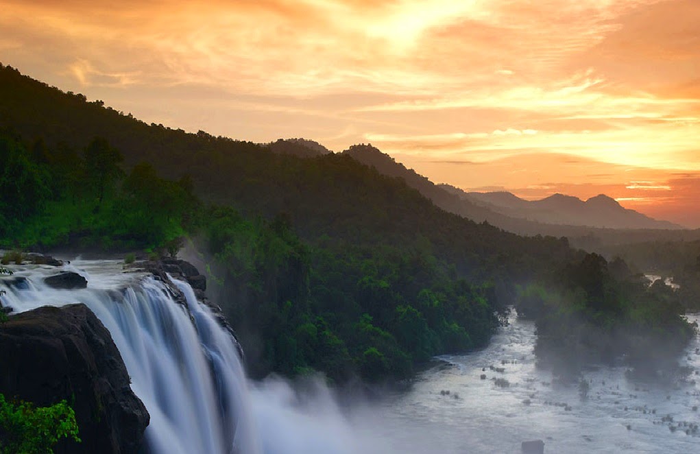
VALARA WATER FALLS

Valara Waterfalls is only about 10 km away from Adimali along the Cochin-Madurai highway. Valara features an astounding chain of waterfalls and provide a particularly magnificent treat for the eye. These waterfalls are surrounded by lush, dense forests that are home to a wide variety of small animals and birds
CHEEYAPPARA WATER FALLS

The famous Cheeyappara Waterfalls of Kerala are somewhere between Neriamangalam and Adimali along the highway linking Cochin and Madurai.The Cheeyappara Waterfalls is one of Kerala's most magnificent waterfalls. You can see water cascading down here over seven steps, providing a truly fantastic spectacle for you to behold! This is certainly a unique spectacle

RAMAKALMEDU

(16 km from Nedumkandam, Thekkady-Munnar Road) Rolling green hills and the fresh mountain air make Ramakalmedu and enchanting retreat. The hilltop also offers a panoramic view of the picturesque villages of Bodi and Cumbum on the eastern slope of the Western Ghats. Distance 45 km from Idukki, 40 km from Thekkady and 75 km from Munnar. Bus timings: 09.30 a.m. Munnar, 10.30 a.m. Kottayam, 09.30 a.m. Ernakulam

Thursday, November 6, 2008
VAGAMON

It is a very ideal tourist spot surrounded by the greenery of tea gardens, beautiful meadows, deep puzzling valleys and dales. The enchanting hill station dotted with tea gardens will soon be one of India's foremost eco-tourism projects. All the trekking enthusiasts will enjoy climbing this 1100 metres tall hill. This tourist place also has to offer Thangal Para, the Indo-Swiss Project and Kurisumala Ashram. Welcome to a land which would make you come back again and again. So that you could rejuvenate yourself and cherish memories of this enchantingly beautiful land.Grass covered hills, velvet lawns and the cool mountain air make Vagamon a perfect holiday retreat. A curious blend of religious mysticism and European legacies, this hillside village is a haven of tranquility. The chain of three hills - Thangal Hill, Murugan Hill and Kurisumala - is a mark of religious harmony. The dairy farm managed by the Kurisumala monks is worth a visit.

ANAMUDI


Anamudi (Anamudi in Malayalam meaning The Elephant Peak and Anai mudi in Tamil, meaning elephant's brow is the highest peak in the Western Ghats in India, having an elevation of 2,695 metres (8,842 ft). It is located in the southern region of Eravikulam National Park at the junction of the Cardamom Hills, the Anaimalai Hills and the Palni Hills. The nearest town is Munnar, 13km away.

Wednesday, November 5, 2008
NEELAKURINJI


Kerala is blessed with many natural spectacles and among them is a unique canvas that gets unveiled every twelve years in God's Own Country.The phenomenon of once in twelve years occurring on the fabled hills of Munnar is attributed to the blooming of Neelakurinji or passionately called by botanists as ‘Strobilanthes kunthianum.' The flower with 40 odd varieties bloom mostly in shades of blue, and thus in its name Neela in the local language stands for the colour blue and Kurinji the local name for the flower.This year, the hills of Munnar once again have welcomed Neelakurinji on to its bosom after a period of twelve years.Revered by the local tribal community and admired by visitors to these enchanting hills, the blooming of Neelakurinji usually starts from August and would last up to October.Once in Munnar, you may locate the magical blooms of Neelakurinji at Kovilur, Kadavari, Rajamala, Iravikulam National Park, which is home to the endangered mountain ungulate- the 'Nilgiri Tahr' and at other places in and around Munnar. Nature lovers and travelers have already started heading for Munnar to savour in this once-in-twelve-year phenomenon.It is an ethereal experience to stand amidst the sprawling blooms of Neelakurinji. The Neelakurinji plant shows variation in height according to the elevation of the land from the sea level. Usually shorter plants (about 2 ft) are found at the high elevations, while taller ones (about 5 to 10 ft) are seen at lower elevations.Many tour operators, adventure clubs etc. organise trekking for visitors to reach some of the best locales in and around Munnar for seeing the grand spread of Neelakurinji.

PEERUMEDU

Peerumedu is a small hill station, snuggled at an altitude of 914 m above sea level, on way to Thekkady. The famous plantation town takes its name from Peer Mohammad, a Sufi saint and close associate of the erstwhile royal family of Travancore
Clouds drop gently on the peaks that flank the verdant slopes of Peerumedu. Rich with mile upon mile of plantations falling away in precise steps. Coffee, tea, pepper, cardamom and rubber flourish in what is the most fertile part of the Western Ghats. Broken only by spectacular waterfalls in the distance and wide open grasslands in places. On a fairly warm day, the mercury reads between five and ten degrees celsius. Little wonder then, that the former Rajas of Travancore sought this tiny hill station out as their summer resort.

Tuesday, November 4, 2008
MARAYOOR
MARAYOOR


This is the only place in Kerala that has a natural growth of sandalwood trees. The sandalwood factory of the forest department, the caves (Muniyars) with murals and relics from the new Stone Age civilization and the children's' park spread across a hectare of land under the canopy of a single banyan tree are of great interest to tourists.
MATTUPETTY


Located 13Km from the munnar town and situated at a height of 1700 m from sea level.It is famous for its highly specialized dairy farm of the Indo-Swiss Live stock project.More than 100 varieeties of highly cattle are reared here.THe mattupetty lake and Dam are at a short distance from the frarm is apopular picnic spot.The visitors should visit the kundala Tea Plantations and the Kundala lake while on a visit to Mattupetty.

THEKKADY
THEKKADY


Thekkady, is one of India's most fascinating natural wildlife sanctuaries, where you can watch wildlife at close range. The vegetation, the flora and fauna and the birds of Thekkady are uniquely rich, vast and varied that it does not bear semblance to any other wildlife sanctuaries in the world. Even a casual visitor to this place will not fail to observe the special ecological pattern of ThekkadyThekkady - The very sound of the name conjures up images of elephants, unending chains of hill and spice scented plantations. In the crisp, cool air of the Western Ghats you will experience the most enchanting holiday. With the animals of the wild and the simple mountain people. In the Periyar forest of Thekkady is one of the finest wildlife reserves in India, and spread across the entire district are picturesque plantations and hill towns that hold great opportunities for treks and mountain walks. The Thekkady sanctuary is one of the best in the country for watching and photographing wild life. Thekkady is on the border with state of Tamil Nadu , in fact just 5 kilometers from the border town of Kumily which is very well connected by bus to both Kerala and Tamil Nadu. Notable among the denizens of Periyar are the tigers, the majestic Asiatic wild elephants and the distinctive Nilgiri langur. Other animals include the wild boar, wild dog, bison, bear and leopards. Amongst the avifauna, the most profuse are herons, egrets, darters, kingfishers and the great Malabar grey hornbill. A cruise through the waters of Periyar lake around which the wild -life sanctuary is situated, offers a soul - stirring pleasant experience
PERIYAR TIGER RESERVE
Periyar, in Kerala, is the best-known wildlife sanctuary in south India. Though billed as a tiger reserve, Periyar is really famous for its wild elephants, 100-year-old artificial lake and its setting in the beautiful thickly forested Western ghats. This is not your best shot at spotting the Bengal Tiger considering there are less than 40 of them that inhabit an area of 777sq.km but there’s plenty of other game like the Nilgiri langoor, Nilgiri tahr, bison, deer, antelope and about 700 elephants to make the trip worthwhile
CHINNAR WILD LIFE SANCTUARY
CHINNAR WILD LIFE SANCTUARY


Situated on the Tamil Nadu - Kerala border, the wild life Sanctuary is spread across 90.44 sq kms. A thorny shrub jungle present no where else but here, makes this sanctuary unique with a wide range of animals and birds like elephants, porcupine, lion tailed monkeys, jungle fowl, spotted dove, laughing thrush etc.
Chinnar Wildlife Sanctuary is located 18 km north of Marayoor in the Marayoor and Kanthalloor Panchayats of Devikulam Taluk in the Idukki District of Kerala state in South India. It is under the jurisdiction of and contiguous with Eravikulam National Park to the south. Indira Gandhi Wildlife Sanctuary is to the northwest and Kodaikanal Wildlife Sanctuary is to the east. It is one of twelve Wildlife Sanctuaries in Kerala.The Western Ghats, Anamalai Sub-Cluster, including all of Chinnar Wildlife Sanctuary, is under consideration by the UNESCO World Heritage Committee for selection as a World Heritage Site.
Chinnar Wildlife Sanctuary is located 18 km north of Marayoor in the Marayoor and Kanthalloor Panchayats of Devikulam Taluk in the Idukki District of Kerala state in South India. It is under the jurisdiction of and contiguous with Eravikulam National Park to the south. Indira Gandhi Wildlife Sanctuary is to the northwest and Kodaikanal Wildlife Sanctuary is to the east. It is one of twelve Wildlife Sanctuaries in Kerala.The Western Ghats, Anamalai Sub-Cluster, including all of Chinnar Wildlife Sanctuary, is under consideration by the UNESCO World Heritage Committee for selection as a World Heritage Site.
IDUKKI ARCH DAM
IDUKKI ARCH DAM

This is the world's second and Asia's first Arch dam, Constructed across the Kuravan and Kurathi hills. It is 640 feet in breadth and 550 feet in height and this lies close to the Cheruthoni barrage. This dam was constructed along with two other dams at Cheruthony and Kulamavu. Together, the three dams have created an artificial lake that is 60 km² wide. The stored water is used to produce electricity at the Moolamattom Power house, which is located inside nearby rocky caves. The Government of Canada aided in the building of the dam with long term loans and grants

This is the world's second and Asia's first Arch dam, Constructed across the Kuravan and Kurathi hills. It is 640 feet in breadth and 550 feet in height and this lies close to the Cheruthoni barrage. This dam was constructed along with two other dams at Cheruthony and Kulamavu. Together, the three dams have created an artificial lake that is 60 km² wide. The stored water is used to produce electricity at the Moolamattom Power house, which is located inside nearby rocky caves. The Government of Canada aided in the building of the dam with long term loans and grants
Monday, November 3, 2008
ERAVIKULAM NATIONAL PARK

Eravikulam National Park
Is situated in the High Ranges (Kannan Devan Hills) of the Southern Western Ghats in the Devikolam Taluk of Idukki district, Kerala State between 10º 05' - 10º 20' N Latitude and 77º 0' - 77º 10' E Longitude. Etymologically, Eravikulam denotes streams and pools.
The Park is 97 sq. km. in extent, consisting mostly of high altitude grasslands that are interspersed with sholas. The main body of the National Park comprising of a high rolling plateau with a base elevation of about 2000 meters from mean sea level. The Park is of undulating terrain and the highest peak is Anamudi (2690 m). Three major types of plant communities are found in the Park-grasslands, shrub land and forests. The high plateau and the hills rising above it, are primarily covered by grasslands. Shrub lands are seen along the bases of the cliffs. Shola forests are located in the valleys and folds. Turner’s valley, which splits the Park roughly in half from northwest to southeast, is the deepest.
The park is accessible from Kochi (Kerala) and Coimbatore (Tamil Nadu) airports, which are located at about 148 Km and 175 Km respectively. Munnar is the nearest town (13km.), well connected by roads from Kerala and Tamil Nadu. The nearest railway station in Kerala is Aluva (120 Km away from Munnar) and in Tamil Nadu is Coimbatore (165 Km)
The only motorable road inside the Park, passes through the southern extremity inside the tourism zone (Rajamala) to the Rajamallay tea estate. Another road head leads to the Lakkom Muduvakudy on the periphery and is not usable at present. All other movements inside the Park are on foot along trails and footpaths.
The Park is 97 sq. km. in extent, consisting mostly of high altitude grasslands that are interspersed with sholas. The main body of the National Park comprising of a high rolling plateau with a base elevation of about 2000 meters from mean sea level. The Park is of undulating terrain and the highest peak is Anamudi (2690 m). Three major types of plant communities are found in the Park-grasslands, shrub land and forests. The high plateau and the hills rising above it, are primarily covered by grasslands. Shrub lands are seen along the bases of the cliffs. Shola forests are located in the valleys and folds. Turner’s valley, which splits the Park roughly in half from northwest to southeast, is the deepest.
The park is accessible from Kochi (Kerala) and Coimbatore (Tamil Nadu) airports, which are located at about 148 Km and 175 Km respectively. Munnar is the nearest town (13km.), well connected by roads from Kerala and Tamil Nadu. The nearest railway station in Kerala is Aluva (120 Km away from Munnar) and in Tamil Nadu is Coimbatore (165 Km)
The only motorable road inside the Park, passes through the southern extremity inside the tourism zone (Rajamala) to the Rajamallay tea estate. Another road head leads to the Lakkom Muduvakudy on the periphery and is not usable at present. All other movements inside the Park are on foot along trails and footpaths.

Sunday, November 2, 2008
MUNNAR
MUNNAR


MUNNAR
It is located 1600 meters above sea level , and it is 55 km from idukki town, munnar is situated at the confluence of three mountain streams, this hill station was the summer resort of the British government in south India. Sprawing tea plantations, picture - book towns, winding lanes and holiday facilities make this a popular hill station neelakurinji is the flower which bathes the hills in blue once every twelve years, will bloom next in 2006 AD. Munnar has the highest peak in south India, Anamundi, which rises to a height of 2695 m. Munnar was the most favored summer destination of European settlers for centuries. Munnar actually means the 'Three Rivers' and derives its name from the three-mountain stream, Muthirapuzha, Nallathanni and Kundala. The confluence of these rivers is at the heart of the town and they fulfill all the water requirements of the town.
Devikulam
Pallivasal:
Chithirapuram:


MUNNAR
It is located 1600 meters above sea level , and it is 55 km from idukki town, munnar is situated at the confluence of three mountain streams, this hill station was the summer resort of the British government in south India. Sprawing tea plantations, picture - book towns, winding lanes and holiday facilities make this a popular hill station neelakurinji is the flower which bathes the hills in blue once every twelve years, will bloom next in 2006 AD. Munnar has the highest peak in south India, Anamundi, which rises to a height of 2695 m. Munnar was the most favored summer destination of European settlers for centuries. Munnar actually means the 'Three Rivers' and derives its name from the three-mountain stream, Muthirapuzha, Nallathanni and Kundala. The confluence of these rivers is at the heart of the town and they fulfill all the water requirements of the town.
Devikulam
Situated 16kms south-west of Munnar, is a small hill station Devikulam , is another hill station known for its green meadows,. The Sita Devi Lake is good choice for picnic. The water of the lake has minerals, which contains curative properties. The lake is also ideal for trout fishing., “Devikulam” means 'Pond of the Goddess', as it is believed that goddess Sita once, had a bath in the pond near by and hence this place was named after it. This place has a lot of natural beauty and many tourists come here to enjoy its serenity
Pallivasal:
8 km from Munnar, is the venue of the first Hydro Electric Project in Kerala. The place is also famous for its natural beauty.
Chithirapuram:
10 km far from Munnar, reflects the colonial charm with the presence of the cottages, bungalows, old playgrounds and courts. One can see Home of the pallyvasal hydel power project, this hill town is also famous for its charming tea plantationTravel to Chithirapuram and take in a world of experiences in outdoor activities such as hiking and trekking..Attukal: Located 9 km from Munnar, must be visited for its charming sceneries, waterfalls and rolling hills. Attukal is located between Munnar and Pallivasal and it is very calm and quite place
Nyayamakad:
Located 10 km from Munnar, is placed between Munnar and Rajamala. The place is famous for several splendid waterfalls. The waters come down a hill from a height of almost 1600 m. The enchanting surroundings make an excellent picnic spot and trekking point.


Subscribe to:
Posts (Atom)